/prod01/prodbucket01/media/durham-university/departments-/geography/Matt_Couchmann-3872X1296.JPG)
Geography Available Research Project
Sediment supply by debris flows to headwater channels in the Indian Himalaya
Project overview
Catastrophic sediment-laden floods pose a significant hazard in High Mountain Asia. In 2021, a debris flood in Melamchi, Nepal, inundated hundreds of homes and led to 25 fatalities. Post-event surveys show that the initial flood was particularly erosive in headwater channels, entraining up to 40 meters of sediment to catastrophically bulk in size before traversing downstream (Chen et al., 2025). To identify channels susceptible to sediment-laden floods in the future, we must therefore constrain sediment supply and storage in headwater channels.
Debris flows supply sediment to headwater channels in the Indian Himalaya. However, our understanding of debris flows in these high elevation catchments is limited due to cloudy satellite imagery, inaccessible field locations and sparse vegetation, meaning that many semi-automated approaches to map sediment are inaccurate. This project will produce multi-temporal debris flow inventories for two sub-catchments of the Alaknanda Basin. Two sediment-laden floods have been triggered in sub-catchments of the Alaknanda in recent years, both of which remobilised large volumes of landslide and channel sediment (Champati Ray et al., 2016; Shugar et al., 2021). These inventories will be used to provide a first-order estimate of debris flow magnitude-frequency as well as to quantify the role of debris flows in supplying sediment to headwater channels. The project will use high resolution imagery (e.g. Planet) and topographic data to explore whether debris flows with certain characteristics are more frequent or have higher connectivity to the channel. These findings will also contribute to better constraining debris flow hazard in the Higher Himalayas.
Key references
Champati Ray, P. K., Chattoraj, S. L., Bisht, M. P. S., Kannaujiya, S., Pandey, K., & Goswami, A. (2016). Kedarnath disaster 2013: causes and consequences using remote sensing inputs. Natural Hazards, 81(1), 227–243. https://doi.org/10.1007/s11069-015-2076-0
Chen, C.-M., Hollingsworth, J., Clark, M. K., Chamlagain, D., Bista, S., Zekkos, D., et al. (2025). Erosional cascade during the 2021 Melamchi flood. Nature Geoscience, 18(1), 32–36. https://doi.org/10.1038/s41561-024-01596-x
Shugar, D. H., Jacquemart, M., Shean, D., Bhushan, S., Upadhyay, K., Sattar, A., et al. (2021). A massive rock and ice avalanche caused the 2021 disaster at Chamoli, Indian Himalaya. Science, 373(6552), 300–306. Retrieved from https://doi.org/10.1126/science.abh4455
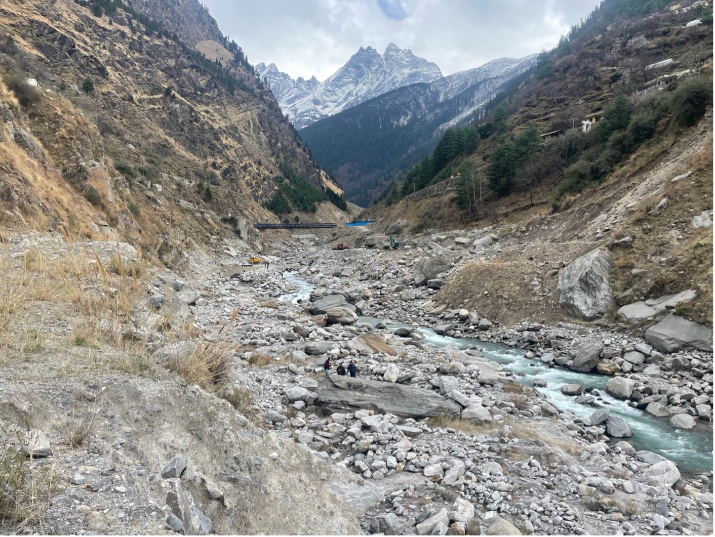
Photo looking upstream towards the Rishiganga catchment, an example of a high elevation catchment for which we have limited knowledge of debris flow processes. The channel is filled with sediment from a sediment-rich flow event in February 2021 (photo taken March 2025). People can be seen for scale. Photo credit: E. Harvey.
/prod01/prodbucket01/media/durham-university/departments-/geography/geographymres/wodroffe_moffa-sanchez1.jpg)
Available Research Projects
See all of the currently available research projects that are recruiting students.
/prod01/prodbucket01/media/durham-university/departments-/geography/76251%5B1%5D.jpg)
Research Masters
Our Research Masters provides an opportunity to develop your research expertise and advanced skills. Pursue your own top or collaborate on a project designed by a supervisor in our world-leading research environment.
Contact Us
Founded in 1928, the Department of Geography at Durham University is one of the leading centres of geographical research and education in the world.
Department of Geography
Postgraduate Study
Durham University
Lower Mountjoy
South Road, Durham
DH1 3LE, UK
Tel: +44 (0)191 33418000
Be social. Be informed. Be a part of Durham Geography.


